
PHOTOS AND STORY BY ULYANA HORODYSKYJ '07
[This story was originally published in the Fall 2014 issue of Rice Magazine.]
Ulyana Horodyskyj ’07 goes to extreme measures to collect data on climate change in some of the world’s most forbidding mountainous environments. Though perilous at times, the fieldwork of climber scientists like Horodyskyj is critical to understanding the causes and implications of glacial melting throughout these sensitive — and exquisitely beautiful — ecosystems.
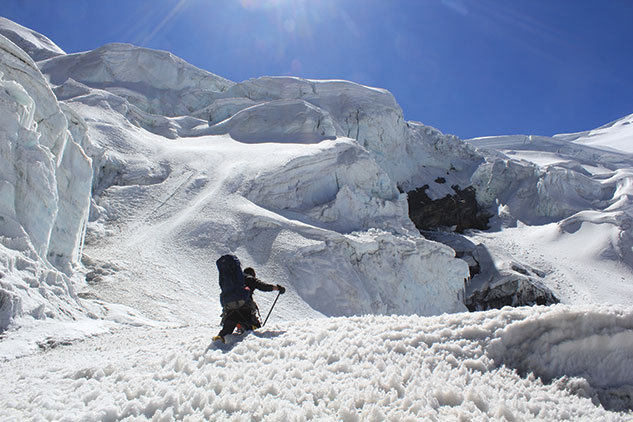
Postholing, or sinking knee- or thigh-deep into loosely packed snow accumulation, is occasionally a fact of life for climbers in the unforgiving landscape of the Himalaya.
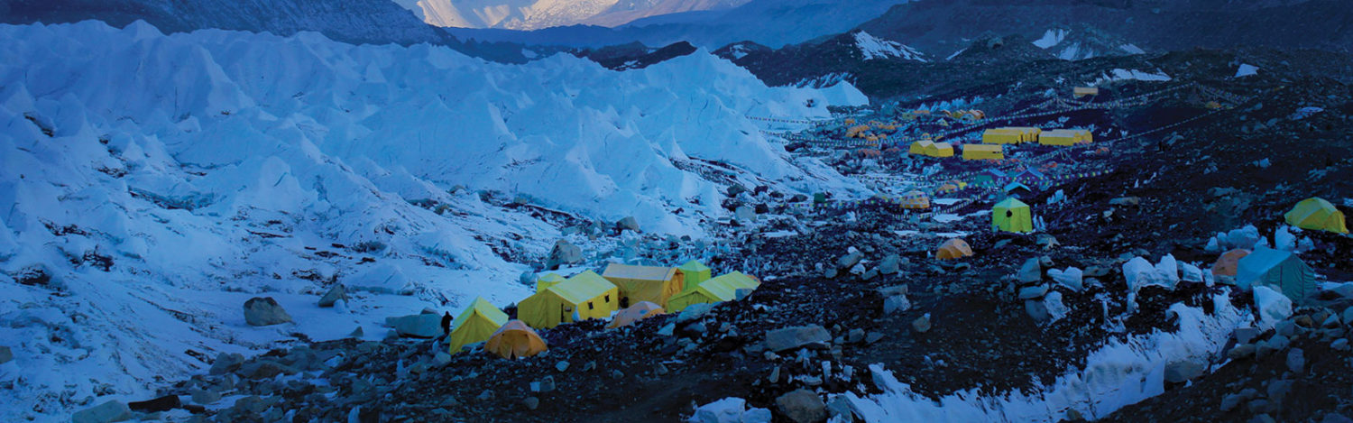
In the early morning hours of April 18, 2014, in the Nepalese Himalaya, I rolled over in bed in a lodge 14,000 feet in the mountains and hit the snooze button. The sun was shining in a brilliant blue sky. The wind, strong and cold. I started off the brisk morning with a cup of hot chocolate, briefly running through a checklist in my notebook: get to Everest base camp, just a few hours’ walk away now, join the rest of the Sherpa team, unpack all the scientific gear and run diagnostics on electronics.
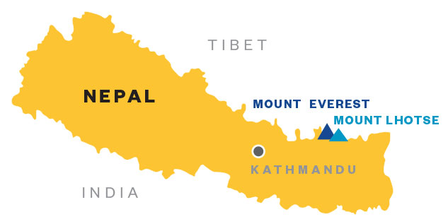
I was trekking and climbing in this mystical landscape as a member of the American Climber Science Program (ACSP), a nonprofit organization that brings together scientists, climbers and other volunteers from all walks of life to conduct research in high alpine environments. After a year of especially intense (and sometimes harrowing) training and preparation, I was excited, but also a bit nervous, to be on my first peaks above 24,000 feet (Mount Everest is 29,029 feet high and Lhotse is 27,940 feet). Our team’s mission was to do groundbreaking scientific work on the effect of pollution on snow and ice in the high Himalaya.
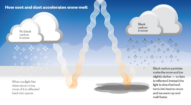
The driving force behind the expedition was to learn how pollution from black carbon (soot) and dust can hasten melting in different altitudinal zones on the Khumbu Glacier and Western Cwm of Mount Everest. Sources for black carbon include cars and motorbikes, industrial factories, forest fires, road construction and other land use development. These dark particles absorb solar radiation, just like your body does when wearing a dark versus light shirt. The more heat that gets absorbed, the more melting can occur.
Why does this matter? Glaciers grow by accumulating snow. As more snow falls, it gets compressed and turned into ice, slowly flowing downhill. Thus, the more snow that melts up top, the less there is to create a new glacier. On the other ends of glaciers, large lakes are growing and deepening with time, leading to even more ice mass loss and resulting in flood hazards to villages and cities down-valley. Together, the whole glacial system is in distress, warranting greater scientific attention.
My fellow climbers included John All, an associate professor of geography from Western Kentucky University, executive director of the ACSP and the leader on this expedition; volunteer climbers and scientists Chris Cosgriff from Washington, Jake St. Pierre from New Hampshire and David Byrne from Oregon; and Nepali support team members Anil Bhattarai, Ashman Tamang, Lama Sherpa and Endra Gurung, employees of Himalayan Ecstasy Nepal, a Kathmandu-based trekking and climbing operator. Carl Schmitt, project scientist at the National Center for Atmospheric Research, provided ground support.
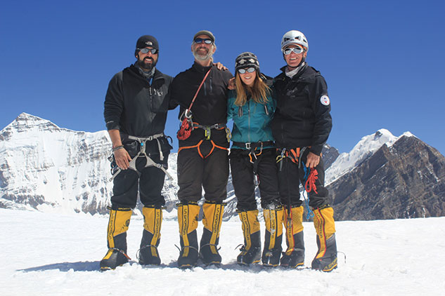
Left to right: Jake St. Pierre, David Byrne, Ulyana Horodyskyj and Chris Cosgriff
The data we planned to collect would add crucial information to my doctoral research at the University of Colorado at Boulder, where I am finishing my dissertation. All these details were in the back of my mind as we (Jake, Chris, David and I) headed out and up toward Everest’s crowded base camp, which on that morning had witnessed a terrible loss of life.
Along the trek, we soon learned that an ice serac had collapsed earlier that morning, causing an avalanche that buried 16 climbers in the Khumbu Icefall; these men had been fixing ladders and were en route to Camp 2 to drop off supplies. Helicopters brought bodies down from the accident site to a makeshift morgue and also rescued the few survivors. The rhythmic sound of spinning blades contrasted with the chaos of 16 climbers dead. We were heartbroken to learn that one of our own young team members, Ashman Tamang, was killed on impact. It was the single deadliest day for climbers in Everest’s history.
In the midst of lingering grief and shock, we tried to focus on work — gathering snow samples and other data in the lower reaches of the mountain. The process was mechanical, mostly a way to try to get our minds off of what had happened. Day by day, more and more teams left base camp, until it was virtually a ghost town. We could not, in good conscience, continue our climb, and so we too headed back down to Kathmandu to consider our next steps.
A Season of Research
 Before joining the ACSP team on Everest in April, I had spent the better part of eight months in the Himalayan mountains as a Fulbright scholar, trekking more than 750 miles through the hills and valleys in central and eastern Nepal with Western and Sherpa field assistants. I spent most of my time documenting glacial lake changes on Ngozumpa, one of Nepal’s largest and longest glaciers, as well as collecting snow samples from lower peaks (Island Peak, Lobuche East), mountain passes (the Cho La) and villages (Gokyo, Tangnak, Chukkhung) at altitudes ranging from 15,000 to 20,150 feet. Although I had spent the previous July in Peru’s Cordillera Blanca, training to sample glacier contaminants with another American Climber Science expedition, the research on glacial lakes was my main focus in Nepal. In October, something unexpected happened that would send me to research “black ice” at even higher altitudes in the Western Cwm and South Col of Everest, locations that had not been sampled before.
While I was leading a trek to lakes on the Ngozumpa Glacier, our group was taken by surprise when a lingering cyclone off the coast of India made landfall and slammed against the Himalaya, dumping three feet of snow in just two days. This led to treacherous trail conditions, including avalanche tracks stopping mere feet from the trail and postholing through the snow, sometimes up to midthigh. At one point, I resorted to crawling. The greater surface area kept me from falling through the snow.
The glacial lakes we were trekking to were partially frozen, and we could not get to instruments I had placed there earlier. We set up a new station to track snowmelt over time and collected snow samples just days after the storm to look for soot and other contaminants. The station included a camera to track weather changes and snowmelt; an air temperature/relative humidity probe; and two pyranometers, instruments that measure albedo or reflectivity. (Fresh snow has a relatively high reflectivity, sometimes upward of 90 percent. Accumulation of dark particles can lower this significantly, leading to melting.)
What seemed at first like a major setback for data collection ended up giving me valuable and unanticipated measurements from the cyclone.
When I returned to the region later that winter, I downloaded the station data and noticed, despite dropping temperatures, the pyranometers had recorded a 20 percent decrease in albedo. The three feet of snow that fell in October had mostly melted away — and the remainder was very dirty.
This analysis is still in progress to determine if soot or dust is the dominant component in the snowmelt. If the former, this may indicate long-range transport of pollution, either from Europe or other regions in Asia. For the latter, the data may indicate a more localized effect, but one that still warrants attention.
I was not only collecting snow samples and honing field techniques, but also strengthening and conditioning my body. Sometimes I would carry loads up to 45 pounds to the base camps — either to train or, sometimes, because of lack of funds to pay for extra support after federal funding had fallen through. Higher up on the mountains, where Sherpa assistance was needed, I could not compromise safety, so a little creative fundraising was in order. Thus, in December, I hosted the first “Glacier Olympics” and raised about $800. While locals and foreign trekkers competed for medals on the ground in speed tent setup, boat pull and overhand ice axe throw events, remote participants could buy in and bet on the ice curling event to win gift cards.
My mentor, David Breashears, the filmmaker and mountaineer, always talks to me about being mentally strong, and matching abilities with ambitions. I feel the challenges we encountered during the eight months prior to Everest taught me how to continue on in the face of great tragedy and adversity.
From Kathmandu to Himlung
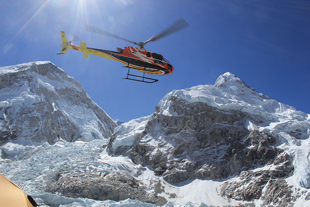
A helicopter transports climbers’ gear from Everest base camp to Kathmandu in late April. Following the April 18, 2014, avalanche on Everest that killed 16 climbers, the ACSP team canceled their planned ascent.
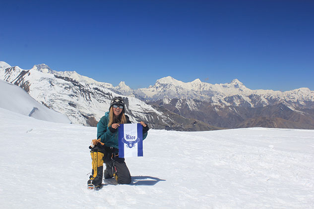
Back in Kathmandu, our team decided to travel to another peak to meet our scientific objectives, this one up the NarPhu valley and close to the Tibetan border. Called Mount Himlung, it stands nearly 23,500 feet, and, while not quite giving us the extreme altitudes we had wanted, Himlung would work as a new spatial data point, given its location in central Nepal.
The journey from Kathmandu included eight hours in a van and then eight more bone-jarring hours in a Jeep, driving on roads with thousand-foot drop-offs. Our arrival at the trailhead was met with relief, albeit temporarily. There was still a 25-mile hike to the base of the mountain, with a lot of rough terrain in between. While donkeys carried our climbing and camping gear and two weeks’ worth of food (rice, potatoes, vegetables and raw chicken), we carried the fragile electronics on our backs.
Given the approaching monsoon season, it was important for us to get set up on the mountain. We had already spent weeks at high altitude, so we were acclimatized and able to carry heavy loads to our camps without Sherpa support. This was not an ideal situation, but, given no refunds for Everest, we could no longer afford Sherpa assistance.
On Himlung, the strategy was to establish three camps before pushing on to the summit, all the while collecting snow samples at different altitudes. We were making decent progress, considering the state of the route: large crevasses widening as the days progressed; snow darkening underfoot and turning to slush, even in the morning hours. After a particularly exhausting haul up to Camp 2 and a heart-stopping descent (where I went for an unintentional vertical ride down a slushy slope), we arrived back at Camp 1.
The next morning, exhausted, Jake and I returned to base camp to rest, re-evaluate and gather some more group gear, which included extra fuel for cooking and our last tent for Camp 3. John headed back to Camp 2, deciding to do a bit of route-finding and snow sampling.
On the morning of May 19, as Jake and I were making our way back up to Camp 2, carefully navigating the crevasse maze, we heard a helicopter in the distance. At first, I did not think much of it, but a few minutes later, it turned toward us, until it was right overhead. My heart sank. We watched as the helicopter continued on up the mountain, landed near Camp 2, and then took off about 15 minutes later. We dropped our gear and headed back down to base camp to figure out what a good part of the world had already heard via social media and satellite communication. John had fallen 70 feet into a crevasse and, quite miraculously, climbed out, despite multiple injuries that included broken bones. From the tent, he sent out an emergency message, which posted to Facebook, via a DeLorme satellite phone. Colleagues stateside at the ACSP were the first to see the message and put out the calls to organize the rescue.
As John recovered from his injuries in Kathmandu, our team headed back up the mountain one last time, this time to recover our gear. It was bittersweet. The summit was only a few days away — and we didn’t have enough samples to complete the altitudinal profile. But, given the events of the past two months and the destabilization of the climbing route, it was the correct choice.
What drives me to trek into the Himalaya is the challenge of climbing to extreme altitudes, while having the privilege to conduct research that will bring about change in the way we treat our planet. As temperatures continue to increase and the mountains and glaciers destabilize and adjust to the current climate, the critical need for this research also increases. What kind of legacy will my generation leave behind? I hope it is one of environmental responsibility and stewardship. The time is now.
Growing Into Science
I grew up in a Ukrainian American community in Ohio, the grandchild of immigrants. When I was a child, my father, a civil engineer, and my mother, a music teacher and stay-at-home mom, took my two older brothers and me on trips to teach us about our planet in an experiential manner. When I was just 6 years old, we visited Jungfrau in the Swiss Alps. During a playful snowball fight at 10,000 feet, which my dad caught on film, we witnessed an avalanche in the distance.
At that age, I did not have the capacity to understand what I was witnessing, other than something big and scary-sounding. That childhood experience — where I found that mountains were not only places to learn and have fun, but also places that demanded respect and vigilance — came full circle on my most recent expedition to Everest.
I started out as an astronomy major at Rice, working at the Rice Space Institute and dreaming about exploring space. During my sophomore year, I switched majors to earth science. Under the guidance of Earth Science Professor Cin-Ty Lee, I gained lab experience, wrote and published my first scientific paper, and took part in field trips across the United States, Canada and Belize.
The pinnacle of my undergraduate career, though, was going to Antarctica with John Anderson [Rice’s W. Maurice Ewing Chair in Oceanography] on the Palmer icebreaker. Just a month prior to graduation, I found myself in the land of ice and penguins — a dream come true. Working 12-hour shifts, sometimes outside on the deck of a research ship in -40 C temperatures, and sometimes buried elbow-deep in mud in the ship’s lab, I realized that I could do this for the rest of my life.
The journey of discovery, of approaching the world’s unknowns through creativity and with childlike curiosity — is what I had been searching for and what I found in the middle of the ocean, working in a tiny mobile lab, while studying the effects of climate change in one of the most sensitive regions of the planet. The laws of physics drive glaciers to behave in a certain way. Their secrets are locked in the ice. By treading carefully and with respect, perhaps those secrets get revealed in time. Thus, my life’s journey was revealed while doing sea-level science, and seven years later, it would take me to the top of the world.
Ulyana Horodyskyj ’07 earned a B.S. in earth science and was a resident of Brown College. Her doctoral research has been funded by a USAID Climber-Scientist grant; the Fulbright Program; Hartmut Spetzler, University of Colorado at Boulder; the Rice Space Institute; the Horodyskyj family; and crowd funding from Petridish.org and RocketHub.com. She documents her explorations into the science of climate change in the Himalaya at blackicehimalaya.wordpress.com.


